

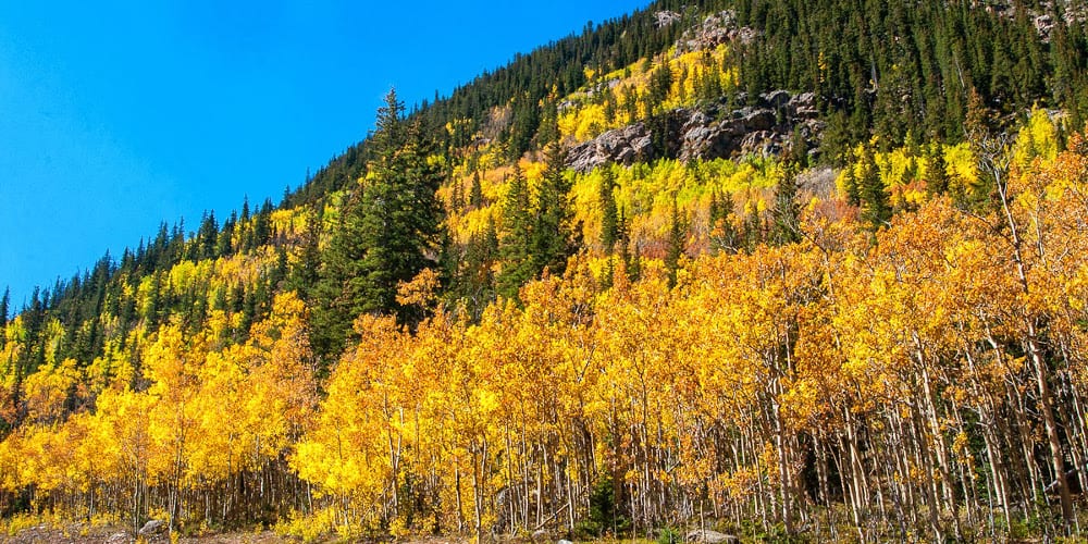
Come September and the aspens begin to glow! Fall is one of the best times to tour the Rockies. The leaves usually begin changing in early September and last no longer than mid-October. It all depends on the weather, so be flexible and ready to travel.
The display begins high up in the mountains and works its way down in elevation as the temperature gets colder. Splashes of yellow, orange, and red all mingle along rolling country roads.
Best Places to See Colorado’s Fall Colors
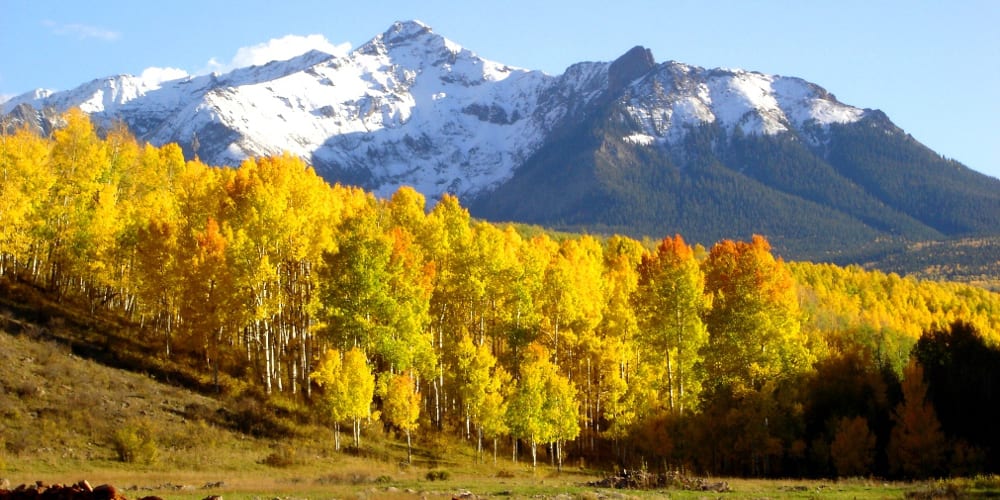
 Autumn colors on Kebler Pass near Crested Butte.
The best places to go are almost anywhere in the mountains. Some scenic drives are better than others, but even a little fall gold will brighten your day. Make sure you take an annual trip into the mountains to witness unmatched autumn in the Rockies.
The following autumn drives are all excellent, but they are only a handful of fall pilgrimages available. These are ones that offer camping nearby and a chance to see a vast amount of colorful trees.
In Northern Colorado
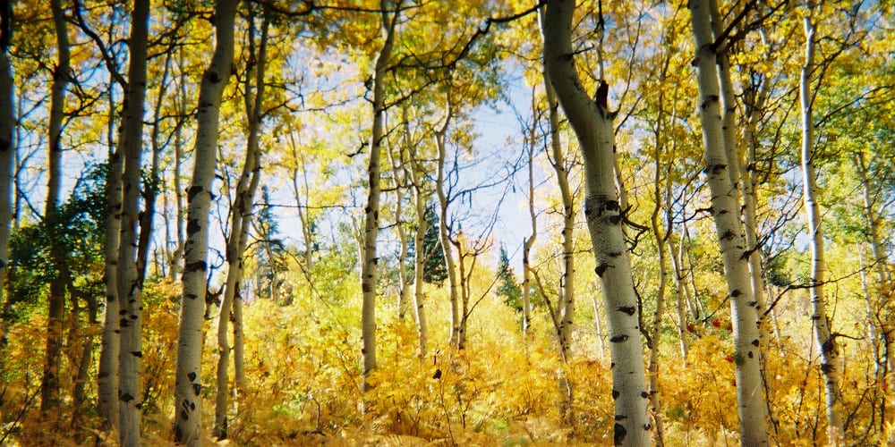 Aspen grove on Buffalo Pass.
1. Trail Ridge Road
Trail Ridge Road winds high through the alpine countryside in Rocky Mountain National Park. Colors fill the hillsides and valleys nearly the whole way.
While not soaking up the scenery, there are numerous things to do in the park, and around Estes Park and Grand Lake. Both towns offer charming historic districts lined with shops and restaurants.
Another perk to the park is the fall elk rut, which generally lasts from mid-September to mid-October. Tens of hundreds of elks gather in one spot, with bull bugling heard from afar.
There’s an entry fee on this one, but on September 24th, 2022 it’s free since that’s National Public Lands Day.
Trip: Estes Park to Grand Lake, 48 miles, 2WD, car fee good for 7 days
Camping: Numerous campgrounds on both sides of the park.
Nearby Drive: Peak To Peak Byway, from Black Hawk to Estes Park, combines well with this route.
2. Buffalo Pass
Situated in Steamboat’s backyard, Buffalo Pass offers remarkable views of the rolling Routt National Forest. It begins winding through aspen groves almost immediately on its way up to 10,400 feet at Summit Lake.
The road begins as a 2WD dirt road but gets progressively more bumpy as you near the top. If going all the way to Walden, it’s best to have higher clearance and 4WD, but you could probably manage with 2WD if you go slow.
Steamboat Springs is loaded with year-round recreation, including two hot springs, Old Town and Strawberry Park, as well as several state parks located in the county. Fish Creek Falls is only a ten-minute hike, and another chance to experience the season close-up.
Trip: Steamboat Springs to Walden, 15 miles (~40 miles to Walden), 2WD/4WD
Camping: Free camping is permitted on Buff Pass, just look for preexisting sites. There are also two campgrounds on the pass, one at the bottom and top. Each is first-come, first-serve. They’re open until mid-October.
Nearby Drive: If you make it all the way to Walden, you can continue east on the Cache La Poudre North Park Byway. It winds 101 miles back to Fort Collins.
3. Flat Tops Trail
Get away from the crowd on the Flat Tops Byway. This long stretch of remote highway passes through two national forests, on its way from Yampa to Meeker. During the journey, you’ll pass by lake after lake, and have ample chances to see the leaves.
Trappers Lake is a short detour from the byway, and a worthwhile stop, though there won’t be too much color due to past forest fires. Open through October, Trappers Lake Lodge has cabins for rent, horseback riding, and a restaurant/bar.
Trip: Yampa to Meeker, 82 miles, 2WD
Camping: You can camp nearly anywhere on the byway. Campgrounds can be found at most of the lakes and dispersed campsites are everywhere.
Nearby Drive: Take CO 13 south toward Rifle for 38 miles, and then left onto CO 325 N. From here you’ll shortly reach three state parks, Rifle Gap, Rifle Falls, and Harvey Gap. The drive between them leads through beautiful landscapes, with a chance to circle back to I-70.
In Central Colorado
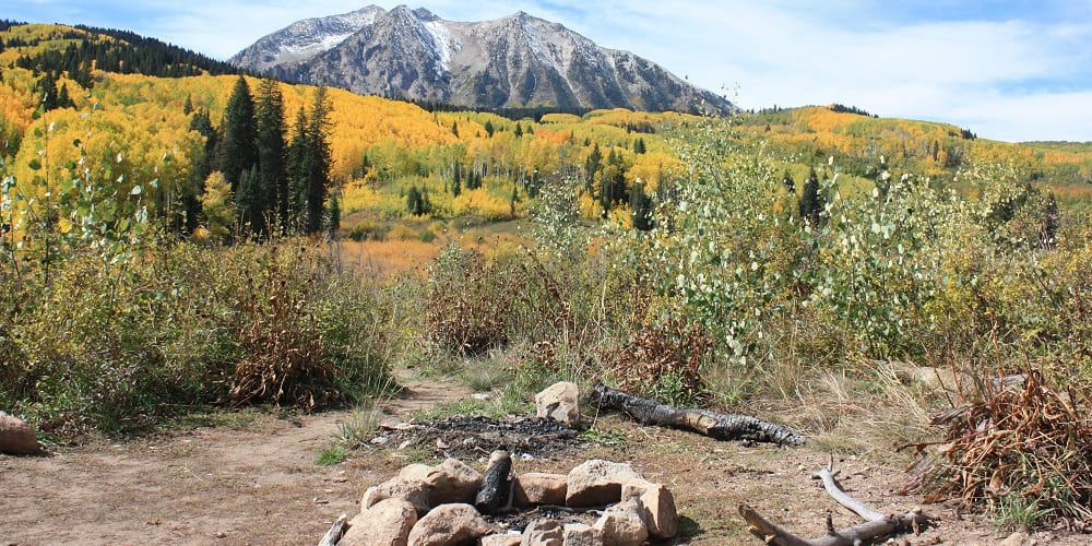 Dispersed camping on Kebler Pass.
4. Independence Pass
A seasonal shortcut to Aspen, Independence Pass climbs to 12,095 feet, providing stunning vistas around every turn. It’s the second highest pass, with an improved road, in Colorado (behind Cottonwood). It generally closes in early November.
Tucked almost halfway between Leadville and Buena Vista, the tiny village of Twin Lakes is home to two giant lakes and an old ghost town. There’s not much commercialization, just a general store, restaurant, and some lodging.
Aspen, on the other hand, is teeming with activity, especially around this time. Maroon Bells is a must-stop in the fall, as well as a great place to camp. On the Aspen side of the pass, the ghost town of Independence is a perfect place to stretch your feet.
Trip: Twin Lakes to Aspen, 36 miles, 2WD
Camping: There are campgrounds near Twin Lakes and on the Aspen side. Dispersed camping is easy to find in the San Isabel National Forest by Twin Lakes.
Nearby Drive: The pass is on the Top Of The Rockies Byway, which heads north past Leadville, over Tennessee Pass, and onto Minturn, by I-70.
5. Kebler Pass
Secluded away in the center of the Rockies, Kebler Pass features lush hillsides of color. You’ll find the most fall foliage on the Paonia side of the pass, although Crested Butte is a town known for its natural beauty. The pass is part of the West Elk Loop, a 205-mile journey through the heart of Colorado.
Considered “Colorado’s last great ski town”, Crested Butte is an impeccable place to spend a few nights. The town is surrounded by some of the most stunning peaks in the state and offers a plethora of dining, shopping, and lodging.
On the western end of Kebler Pass lies Paonia State Park. It’s a quiet park, with access to a 337-acre reservoir open to motor boats. The picturesque town of Paonia is hidden about fifteen miles south of the park, a mile off CO 133.
Trip: Crested Butte to Paonia, 33 miles, 2WD
Camping: Lost Lake CG (nonreservable) and Lake Irwin CG (reservable and open through September) are located on forest roads just off Kebler Pass Road. Free dispersed camping is available throughout.
Nearby Drive: Either before or after Kebler, take Cottonwood Pass, which features wonderful color, and both dispersed camping and campgrounds. It connects Buena Vista with Almont, just south of CB.
Nearby Drive: From Paonia, you can head north on Highway 133 over McClure Pass to Carbondale and back to I-70. Also part of the West Elk Loop, this alpine road winds through a canyon forged by the Crystal River. A good detour before Carbondale is the town of Marble, a mining village stashed a few miles off the highway. There’s a solid BBQ joint in town, and a winding road through the aspens up to the marble quarry.
6. Grand Mesa Byway
The largest flat-topped mountain in the world looks great in the fall. One of the best drives on the Western Slope, Grand Mesa Byway rises quickly to around 11,000 feet above sea level, where it then meanders past lakes and forests. A detour west to Land’s End Overlook, (take Forest Road 100 to 105 for 10 miles/40 minutes) offers expansive views of the colorful valley floor.
Cedaredge has a few nice places to eat and stay, and it’s also not too far from Delta, one of the region’s bigger towns. Mesa, to the north, is a sleepy mountain town with another few places to dine and slumber. From Mesa, you can reach Vega State Park in twenty miles.
Trip: Mesa to Cedaredge, 63 miles, 2WD
Camping: Free and paid campsites can be found on the byway.
Nearby Drive: If you have another night to spend on the road, take the West Elk Loop, south of Cedaredge. Highway 92 passes Crawford (maybe detour at the North Rim of the Black Canyon of the Gunnison) and snakes through the Curecanti National Recreation Area, home of Blue Mesa Reservoir. This will lead you to Gunnison where you can continue east.
In Southern Colorado
 Fall color along Last Dollar Road.
7. Highway Of Legends
Highways Of Legends rolls through the southern foothills of Colorado. It’s an often overlooked destination for those up north, but it’s one of the most scenic and welcoming parts of the state. At its peak on the Cuchara Pass, it reaches 9,938 feet, offering fantastic views of the Sangre de Cristos and Spanish Peaks.
Make a point to stroll through all the historic towns on the way. Situated by I-25, Walsenburg is considered a gateway to the Southwest. In La Veta, you can catch a ride aboard the Rio Grande Scenic Railroad, which departs Alamosa, Fort Garland, and La Veta. Catch fall colors by train that you’d not see from your car.
Cuchara is a delightful mountain village, with a picturesque center of town. You’ll find a couple of good restaurants, a coffee shop, a general store, an inn, and mini golf. At the tale end of the drive, Trinidad’s hillside streets are waiting to be explored.
Trip: Walsenburg to Trinidad, 82 miles, 2WD
Camping: There are plenty of campgrounds on the drive, starting in Walsenburg at Lathrop State Park. Heading south on the byway, you’ll pass Bear Lake and Blue Lake campgrounds, Monument Lake, a private resort with cabins and campsites for rent, a couple of state wildlife areas with campgrounds, and lastly Trinidad Lake.
Nearby Drive: For those looking to complete the whole byway, you can take a detour over the Cordova Pass (peak 11,243 feet). It breaks off east from the Cuchara Pass on its way to I-25 and the town of Aguilar. There’s a campground near the beginning of this rocky, dirt road. Afterward, take I-25 south to Trinidad and take the byway back up to Walsenburg (to get the full tour).
Nearby Drive: Frontier Pathways Byway goes west from Pueblo and runs beside the Wet Mountains, before looping back southeast to Colorado City. It lies only a little bit north of Walsenburg, so it’s a good drive to tack on before or after the Highway of Legends.
8. Alpine Loop 4×4
The rugged Alpine Loop climbs over two 12,000-foot passes, Engineer and Cinnamon, as well as passes by numerous ghost towns and mining camps, including Capitol City and Animas Forks. The one-of-a-kind route was originally used by 19th-century miners working in the remote San Juans.
It’s the only drive on the list that’s designated for high clearance 4x4s. You can begin in either Lake City, Silverton, or Ouray, and you can also rent a Jeep in any of those places. The whole trip takes between four and six hours.
All three towns make a great base camp, each with numerous restaurants, hotels, and attractions. Ouray is known for its giant hot springs swimming pool. The Durango & Silverton Railroad departs Silverton daily through late October. And Lake City is home to one of the largest historic districts in the state.
Trip: Lake City to Ouray to Silverton to Lake City, 63 miles, high clearance 4WD
Camping: Ample camping opportunities exist around all three towns.
Nearby Drive: If beginning in Lake City, you’ll have the pleasure of driving the Silver Thread Byway, which passes by Slumgullion Pass (11,361 feet) and Spring Creek Pass on the way to Creede.
9. Last Dollar Road
A remote backroad from Ridgway to Telluride, Last Dollar Road is the perfect choice for the adventure seeker. It peaks at 10,600 feet, on its bumpy, narrow, dirt route through the majestic San Juan Mountains.
The drive takes between two and three hours and can be impassable when wet (so avoid it if rain is forecasted). A 2WD drive vehicle with high clearance would be okay if it’s dry. It’s also open to unlicensed vehicles, so bring an ATV or dirt bike if you got one.
While in Ridgway, be sure to relax at Orvis Hot Springs, or trek ten miles south to Ouray and soak there. After reaching Telluride, you can ride a free gondola high above the valley floor for incredible aerial views of Telluride’s box canyon.
Trip: Ridgway to Telluride, 21 miles, high clearance 2WD
Camping: Free primitive campsites can be found at various points on the drive. Campgrounds can be found in Ridgway, at Ridgway State Park, or around Telluride.
Nearby Drive: The standard route from Ridgway to Telluride is on the San Juan Skyway, a 236-mile excursion around the Southwest. You can return on the Skyway after Telluride or skip Last Dollar Road completely and ride the byway. The main route is to take Highway 62 from Ridgway to Highway 145, and then onto Telluride. On Highway 62 you’ll pass over Dallas Divide, a phenomenal pass for seeing color. If you keep going south on Highway 145 past Telluride, you’ll climb over Lizard Head Pass, and eventually onto Dolores and Cortez. Drive back east to Durango and you can venture north on US 550, a stretch known as the Million Dollar Highway.
Close To Denver
 Yellow aspen grove on Guanella Pass.
10. Mestaa’Ėhehe Pass
Previously called Squaw Pass, Mestaa’Ėhehe is ideal for those Denverites short on time. You can begin in either Idaho Springs or Evergreen, via CO 103 and Mestaa’Ėhehe (Squaw Pass) Road, respectively. The road is likely still called Squaw Pass Rd.
The drive passes by Echo Lake and Mount Evans Byway (which usually closes in October). Evergreen and Idaho Springs both have nice downtowns with plenty of places to relax and eat during your trip.
Trip: Evergreen to Idaho Springs, 30 miles, 2WD
Camping: Echo Lake Campground closes in early September, but West Chicago Creek Campground stays open through late September. Dispersed camping can be found on both W. Chicago Creek Rd and Hefferman Gulch Rd, north of Echo Lake on CO 103 near Idaho Springs.
Nearby Drive: The Lariat Loop connects Golden, Evergreen, and Morrison. From Evergreen take CO 74 either north to Golden or east to Morrison. If you end in Idaho Springs and still want more, you can head up to Georgetown for Guanella Pass, or over to Black Hawk for the Peak To Peak Byway.
11. Guanella Pass
Guanella Pass is full of autumn color on its hour-long journey from I-70 to US 285. It peaks at 11,670 feet, where Mount Evans and Mount Bierstadt hover in the distance.
Historic Georgetown has numerous restaurants and is home to the Georgetown Loop Railroad, a memorable way to see the sights. In Grant, there’s usually a BBQ stand open at the start of the pass, and a seasonal cafe.
Trip: Georgetown to Grant, 22 miles, 2WD
Camping: Campgrounds and dispersed campsites exist on both sides of the pass.
Nearby Drive: At Grant take a right on US 285 for a fifteen-minute trip up Kenosha Pass. It offers a tremendous view of the valley. Continue west down the pass and you’ll quickly reach Como, a tiny dot on the map. It’s connected to Breckenridge via Boreas Pass (23 miles), another incredible fall trip.
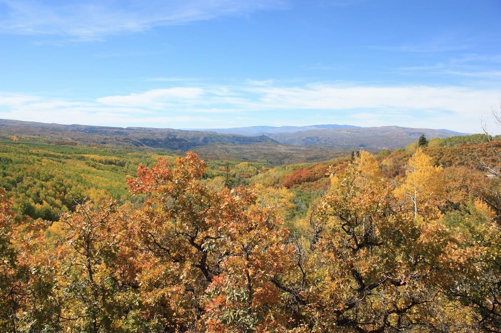
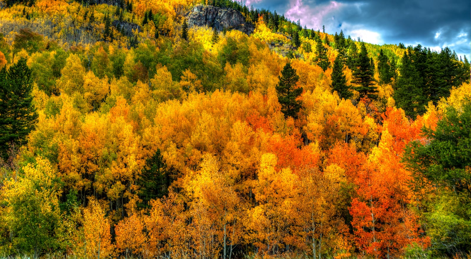 Green, yellow, orange, and red aspens glow in Eagle County, CO. Photo: Gene
Thanks for checking out our list of favorite spots to see the fall foliage! Remember you can’t go wrong if you drive west into the Rockies at the right time of year. You’re bound to see extraordinary fall colors that’ll make you pause and savor autumn.